Day 1 :
Keynote Forum
Adam Lajczak
Pedagogical University of Cracow, Poland
Keynote: Anthropogenic changes in water storage in peat deposit in intramountain orawa – Nowy targ basin (Western Carpathians)
Time : 10:30-11:00

Biography:
Adam Åajczak (Geomorphologist, Hydrologist) is currently the Head of Research in the Department of Geoinformation and Geoenvironment at the Institute of Geography of Pedagogical University in Cracow (Poland). His research is focused on geoecology of mountains and their forelands, rivers valleys and marshy areas. He is a Member of Association of Polish Geomorphologists, International Association of Geomorphologists (IAG), International Association of Hydrological Sciences (Commissions: Continental Erosion and Water Resources) and European Geophysical Union organizations respectively. He started his research in the frames of the project IAG – Anthropocene Geomorphology. In his research much attention is paid to geomorphology, hydrology and paleogeography of peatbogs, especially to anthropogenic degradation of peatbogs and decrease of their water retention. Simultaneously he is engaged in the research on causes, course and results of floods in the valleys of the Carpathians and their northern foreland and on hydrological consequences of progressive decrease of capacity of dam reservoirs due to their siltation.
Abstract:
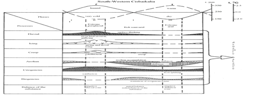
The aim of the presentation is to evaluate the scale of changes in water storage in peat deposit in the Orawa-Nowy Targ Basin (643 km2) off the western Carpathians (European mountain range), influenced by human activity since the middle ages till 2015. The basin is covered by fluvioglacial fans rich in groundwater and stores large amounts of water in vast peatbogs, especially raised bogs. The peatbogs occur at the altitude from 592 to 770 m a.s.l. (metres above sea level) since the middle ages the peatbogs in this basin have been degraded by human impact, mainly due to peat exploitation and drainage by dense network of ditches. After 1990 shrinkage of the limit of peatbog domes slowed down or even stopped and draining ditches are not cleaned which causes increasing irrigation of post-peat areas. Contemporary limit of individual peatbogs and their elements (i.e. reduced domes, post-peat areas, isolated peat patches) in the basin was determined based on data from aerial laser scanning LiDAR (Light Detection and Ranging) and additionally from peatbogs mapping. Former limit of peatbogs was assessed on the basis of historical maps (18th-20th centuries) and mapping of remnants of peat deposit. Using drilling methods, the thickness of peat deposit was measured within each peatbog in the period from August to October (relatively dry deposit). In order to determine the amount of water in peat, four raised bogs and four fens, assumed as representative for the area studied, were sampled in 2008-2015 from May to October (every two months). Using Kopecky`s cells (0.25 dm3), 540 peat samples were taken at the profile depth every 50 cm, which were the bases to calculate capillary capacity of peat in volume version Pwv [%]. Water resources in peatbogs both current and those probable existing before the beginning of the intensive human impact in the basin were estimated based on the appropriate volume of peat deposits and values of capillary water volume of peat Pwv [%]. Finally, maximal amount of water which may be stored in domes (now in residual domes and post-peat areas) and fens was estimated. In the past probable total amount of water which might have been permanently stored in fens in the basin was estimated to 32 million m3, and in the raised bog domes 139 million m3 (together 171 million m3). Total amount of water which is currently stored in fens in the basin is estimated to 15.1 million m3, in raised bog domes to 45.2 million m3, and in post-peat areas to 2.1 million m3 (total volume of water is 62.4 million m3). In relation to the whole area of the basin, the index of water retention of peatbogs reaches 10 cm and at the end of the middle ages this index was probably 27 cm. The fastest rate of water loss in peats occurred 50-150 years ago.
Keynote Forum
Prakash Mehta
IIT Gandhinagar, India
Keynote: Synthesis and characterization of hydrophobic soil and its applications in reducing water evaporation and enhancing growth of plants, water harvesting in construction
Time : 11:20-11:50

Biography:
Prakash Mehta pursued his PhD in Polymer Science from the Polytechnic University, USA (1976); MS in Polymer Engineering from Brooklyn Polytechnic, USA (1974); MS in Inorganic Chemistry at the same university (1973) and MSc in Physical Chemistry from Sardar Patel University, India (1969) respectively. He has over 35 years of experience in USA in R&D, product development and production in the field of organosilanes and silicones technology. He worked at Degussa Corporation (Evonik) for over 28 years. He has developed over 40 organosilanes/silicones commercial products. He is one of the Team Member for the waterproofing product development for the NASA space shuttle. He taught Chemistry (part time) for 25 years at the local universities (Pace University; University of South Alabama, USA respectively). He is the Research Advisor at L D Engineering College and Indian Institute of Technology Gandhinagar, Gujarat, India. He is an Inventor and Developer of Zycosoil (Soil waterproofing), Terasil, Zycotherm, AsphaSeal, AguaProof and TerrenoSeal (Soil waterproofing) commercial products. He has four US patents to his credit.
Abstract:
Plants cannot live without water! and most plants require considerable quantities of water. The amounts needed vary with the types of plants, conditions, stages of growth, rapidity of growth and other factors. Because soils vary greatly in their capacities to absorb and retain moisture, and make it available to plants, it is necessary to consider the soil as well as the plants when dealing with water transport to the plant. With varying patterns of climate changes and variability, water resources for agriculture may become more unpredictable. Food security and water availability for agriculture have become important topics in the wake of global warming and climate changes. Maize ranks third after rice and wheat in terms of cereal crops with global importance. Maize production and productivity both are highly susceptible to drought stress particularly at early growth and silking stage. Increase in plant water availability through technological intervention is the need of time as the country and as the whole world is facing serious issue of decrease in ground water content. Recent development of hydrophobic soil could be one of the major breakthroughs in the area of water conservation as observed in our recent study under controlled conditions using maize as a model crop. Hydrophobic coating with organosilane can certainly reduce the evaporation rate and enhance the vegetative growth of plants. Experiments on morphological and physiological effect of hydrophobic soil on growth of maize using four hydrophobic soil layers (0.5, 1.0, 2.0 and 3.0 cm) on top of normal soil was conducted at Anand Agricultural University, Anand, Gujarat, India revealed significant increase in shoot length, number of leaves and stem diameter which clearly reflected growth promotary effects of hydrophobic layering on normal soil compared to control plants. It showed response in the scale of 1.0>0.5>2.0>3.0 cm of top soil layering. This increase may be attributed due to lesser water stress as experienced by the control plants which showed lesser growth and performance compared to all the soil layering plants. This technology for hydrophobic soil can also be used for natural water harvesting reservoir. Building foundation can be compacted with hydrophobic soil to prevent capillary rise of water into building structures.
Keynote Forum
Sheetal Sharma
International Rice Research Institute, India
Keynote: Catering to high variability and climate change: What next in site specific nutrient management?
Time : 11:50-12:20

Biography:
Sheetal Sharma is a Soil Scientist at International Rice Research Institute (IRRI). She works as an integral part of IRRI Rice Crop Manager Team. She leads the initiatives in South Asia to transform the provision of information to farmers and, to make site-specific recommendations available to small farmers. She majorly works on combining detailed information on crop performance with innovative knowledge transfer approaches and the development of ICT-based decision-support tools suited to extension workers and farmers using mobile applications or computers. The work has targeted small-scale farmers in India, and these applications are enabling farmers to improve the profitability of rice through more timely and accurate crop management. Decision tools have received government endorsement and are now adopted at State level. She is also actively involved in capacity development of local scientists and scholars. She has authored and co-authored more than 20 scientific papers in peer-reviewed journals/book chapters.
Abstract:
Site specific nutrient management (SSNM) in crops is gaining popularity due to its advantage over blanket recommended management practices (BRMPs) as it takes into account site specificity, season and crop growth variability in making soil and crop sustainable. SSNM have proved to increase yield and net profit and has been adopted by various governments and agriculture departments for scaling out. Climate change introduces new dynamics and uncertainties into agriculture production system. It affects agriculture through different means that include changes in average temperature, rainfall and climate extremes, changes in atmospheric carbon dioxide, changes in ozone concentration, changes in pest and diseases and deviations in nutritional quality. Real time climate information can help agriculturalists better manage risk, making the most of favorable climatic conditions while protecting their livelihoods from extreme events. GIS (Geographical Information System) ensures the availability of accurate forecasting of meteorological data, allow for precise predictions of crop water requirements with unprecedented spatial resolution. Remote sensing (RS) can provide the missing spatial information required by crop models for improved yield prediction. The indispensable role of GIS and RS in site-specific nutrient management (SSNM) is efficient use of nutrients for achieving the set target. Use of GIS and RS in the SSNM can do provision for mid-season correction, setting target yield based on local environment and conditions and in generating weather based advisories, leading to balanced nutrient recommendation and ultimately augmenting soil and crop productivity. Nutrient management in stress environment can be managed by the use of mid-season corrections. To improve the crop production and farmer’s income appropriate achievable target yield should be set in the SSNM. Use of GIS can help to set in precise target yield. Overall, use of geo-informatics in SSNM can really boon for sustenance under changing climate and exposing variability.
- Soil Erosion | Water pollution | Soil Degradation | Soil Management | Hydrology | Groundwater Recharge and Water Harvesting | Water Resource Management | Soil Science : Agriculture | Wastewater Treatment | Soil Fertility
Location: Berlin, Germany
Chair
Adam Lajczak
Pedagogical University of Cracow, Poland
Co-Chair
Jean Diatta
Poznan University of Life Sciences, Poland
Session Introduction
Mushombe Muma
New Horizons University, Congo
Title: Assessment of the impact of subsurface agricultural drainage on soil water storage and flow of a small watershed
Time : 12:20-12:40
Biography:
Dr. Mushombe Muma holds a B.A.Sc. Civil Engineering (Université de Moncton, Canada), M.Sc. Civil Engineering (Université Laval, Canada), M.Sc. Environmental Sciences (Université de Québec à Trois-Rivières, Canada), and Ph.D. Water Sciences (Institute National de la Recherche Scientifique, Centre Eau Terre Environnement, Université du Québec). From October 2016, he is an Associate Professor at the Université Nouveaux Horizons in Lubumbashi (Democratic Republic of Congo). He has been a Research Assistant to the Agriculture and Agri-Food Canada project: “Watershed Evaluation of Beneficial Management Practices” from 2009 to 2013. His research works published (more than 12 publications in international scientific journals) or presented at the conferences include the modeling of subsurface agricultural drainage, hydrological model sensibility analysis, effects of the change from forest to agricultural land use among others.
Abstract:
Site specific nutrient management (SSNM) in crops is gaining popularity due to its advantage over blanket recommended management practices (BRMPs) as it takes into account site specificity, season and crop growth variability in making soil and crop sustainable. SSNM have proved to increase yield and net profit and has been adopted by various governments and agriculture departments for scaling out. Climate change introduces new dynamics and uncertainties into agriculture production system. It affects agriculture through different means that include changes in average temperature, rainfall and climate extremes, changes in atmospheric carbon dioxide, changes in ozone concentration, changes in pest and diseases and deviations in nutritional quality. Real time climate information can help agriculturalists better manage risk, making the most of favorable climatic conditions while protecting their livelihoods from extreme events. GIS (Geographical Information System) ensures the availability of accurate forecasting of meteorological data, allow for precise predictions of crop water requirements with unprecedented spatial resolution. Remote sensing (RS) can provide the missing spatial information required by crop models for improved yield prediction. The indispensable role of GIS and RS in site-specific nutrient management (SSNM) is efficient use of nutrients for achieving the set target. Use of GIS and RS in the SSNM can do provision for mid-season correction, setting target yield based on local environment and conditions and in generating weather based advisories, leading to balanced nutrient recommendation and ultimately augmenting soil and crop productivity. Nutrient management in stress environment can be managed by the use of mid-season corrections. To improve the crop production and farmer’s income appropriate achievable target yield should be set in the SSNM. Use of GIS can help to set in precise target yield. Overall, use of geo-informatics in SSNM can really boon for sustenance under changing climate and exposing variability.
Yoshitaka Uchida
Hokkaido University, Japan
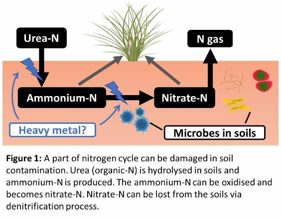
Title: Fate of 15N labelled urea in a soil contaminated by heavy metal containing dust: An incubation study using a mine slag sampled from Kabwe city, Zambia, Africa
Time : 12:40-13:00
Biography:
Yoshitaka Uchida is currently an Associate Professor of Research Faculty of Agriculture at Hokkaido University, Japan. He has been studying soil microbes in relation particularly to nitrogen and carbon cycles. Recently, he started a project in Kabwe city, Zambia targeting a heavy metal contaminated soil and believes the recovery of plants and healthy soils is the key for the success of this project. In this study, he and his student used 15N-labelling approaches to evaluate the sensitivity of N cycle against heavy metals. The project will continue and he hopes to scale-up the experiments at the field level.
Abstract:
Statement of the Problem: Heavy metal contamination of soils is a global issue, particularly around mining sites. The heavy metals can decrease plant and microbial activities in soils and this can be an issue to recover the slag (mine waste) damping site using plants. With decreased plant and microbial activities, nutrients such as nitrogen (N) cannot properly cycle in soils. In N cycle, organic-N such as urea is decomposed in soils by microbes and becomes available to some plants as ammonium (NH4+). Ammonium-N can further be oxidized by nitrifying microbes and becomes nitrate-N (NO3−-N). These processes are extremely important in soils and must be maintained in soil. Thus, the purpose of this study is to evaluate soil microbial activities with increasing contamination levels by a slag.
Methodology & Theoretical Orientation: We conducted an incubation experiment to investigate the effect of slag containing Pb and Zn (100‒3000 and 54‒1620 mg/kg respectively), sampled from a site formerly used as a lead and zinc mine. After two weeks of the pre-incubation, 15N labeled urea (500 mg-N/kg) was added to the soil. Then changes in bacterial relative abundance, the concentration and 15N ratio of NO3−-N and NH4+-N were measured.
Findings: Increasing ratio of slag to soil had a stronger negative effect on nitrification. The bacterial community was significantly influenced by the presence of slag. Firmicutes had a positive and Planctomycetes had a negative correlation with the concentration of heavy metals.
Conclusion & Significance: We concluded that increased contamination levels by a slag in soil had a considerable impact on N dynamics in the soil. However, the sensitivities of the N cycle processes markedly varied. Mechanisms behind this variability needs to be further studied.
Elizaveta Tyumentseva
Irkutsk State University, Russia
Title: Soil erosion: The siberian agricultural lands in Russia
Time : 13:45-14:05
Biography:
Tyumentseva Elizaveta M. is an associate professor of geographical sciences at Irkutsk State University. She is a candidate of Geographical Sciences. Tyumentseva is a specialist in the field of physical geography and geomorphology. She has been studying the morphology and dynamics of erosion relief, erosion and deflation of soils in Siberia for the past 40 years. She implemented experimental studies of soil erosion on virgin lands and agricultural lands at the Institute of Geography of the Siberian Branch of the Russian Academy of Sciences in different regions of Siberia. She is the author of more than 100 articles on soil erosion, deflation and ravine issues. She has published in leading Russian and foreign journals.
Abstract:
Regional features of sheet and gully erosion are presented. In the Asian part of Russia scales of soil degradation degree are determined on the basis of generalization of soil and gully erosion long-term studies. Soil degradation occurs in the southern semi-arid and semi-humid regions, where agricultural arable lands are located. They (lands) occupy 24 million ha. Among them 9 million ha exposed of soil and gully erosion in varying degrees. We determine difference degradation processes mechanisms from west to east. In the Western Siberia dominate meltwater erosion. In the Middle Siberia soil erosion is caused by meltwater and rainstorm runoff, in the Eastern Siberia – rainstorm discharge is observed. Agricultural lands in mountain locate in inter-mountain basins; notes concentric zoning of changes in mechanisms and rate of land degradation. In the central part of basin dominate aeolian processes, on piedmont plains - sheet and gully erosion. At present day on 15 million ha can be erosion. Were analyzed long-term dynamics of erosion processes based on water discharge and sediment load data for 18 drainage basins. The sharp reduction of soil erosion was determined in the Baikal Lake drainage basin, associated with economic activity conservation since 1990. Predictive estimation of soil loss, using quantitative empirical models of the erosional processes was made. We composed maps of erosion-hazardous for agricultural lands. Erosion danger of lands zoning of the South of Siberia was performed. Six categories of desertification probability in semiarid regions of Siberia, caused by soil erosion, was determined. Altaian model of soil protection from snowmelt sheet erosion, Khakassian model of soil protection from deflation and the Baikal models of soil protection from erosion and deflation were presented. They propose most rational regional optimal conditions for agricultural land cultivation, provide sustainable efficient agriculture and soil conservation.
Alina Catrinel Ion
Politehnica University of Bucharest, Romania
Title: Effects of environmental parameters of natural waters on the adsorption of organic contaminants by carbon nanomaterials
Time : 14:05-14:25
Biography:
Alina Catrinel Ion has her expertise in studying the environmental applications of certain types of carbon based nanomaterials. Her scientific interests include determination of organic pollutants in atmospheric environment; characterization and measurements of nanostructures and carbon nanostructures and their food and environmental applications
Abstract:
The sorption of hydrophobic organic contaminants such as triclocarban (TCC), in aqueous solutions and in natural waters on carbon nanomaterials was studied. In the synthetic aqueous solutions, humic acid (HA) as model natural organic matter, triclocarban (TCC), as a hydrophobic organic contaminant and fullerene C60 (weathered by mimicking environmental conditions) were used. The natural waters were completely characterized before the sorption experiments. The effects of ionic strength, concentration of organic matter and of the pH over the adsorption of TCC on the carbon nanomaterial selected in these experiments, C60 were studied. A model for the adsorption mechanism, as well as an attempt to mimic the real environmental samples with characteristics alike to the optimum ones found in the synthetic samples was developed.
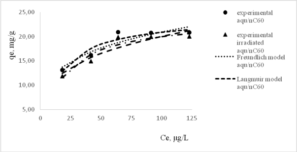
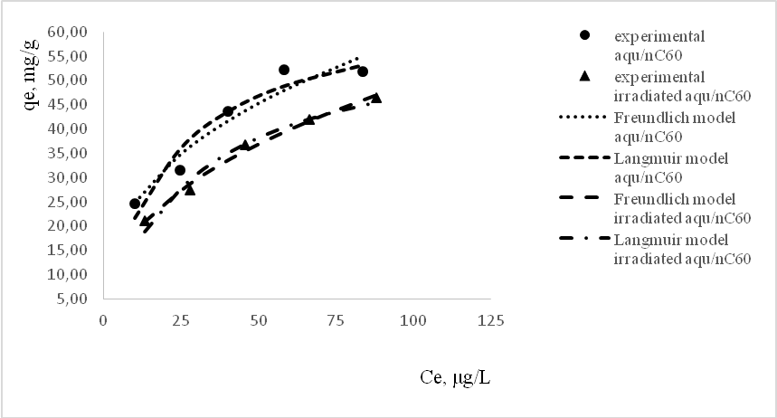
Figure 1: Langmuir and Freundlich non-linear adsorption isotherms of TCC on pristine and irradiated aqu/nC 60; Conditions: Ci=25-125 mg/L TCC, t=5°C (a), 25°C (b), 0.01 M NaCl, 10 mg/L HA, contact time 5 hours, equilibrium reached after 30 minutes.
Alina Catrinel Ion
Politehnica University of Bucharest, Romania
Title: Effects of environmental parameters of natural waters on the adsorption of organic contaminants by carbon nanomaterials
Biography:
Alina Catrinel Ion has her expertise in studying the environmental applications of certain types of carbon based nanomaterials. Her scientific interests include determination of organic pollutants in atmospheric environment; characterization and measurements of nanostructures and carbon nanostructures and their food and environmental applications
Abstract:
The sorption of hydrophobic organic contaminants such as triclocarban (TCC), in aqueous solutions and in natural waters on carbon nanomaterials was studied. In the synthetic aqueous solutions, humic acid (HA) as model natural organic matter, triclocarban (TCC), as a hydrophobic organic contaminant and fullerene C60 (weathered by mimicking environmental conditions) were used. The natural waters were completely characterized before the sorption experiments. The effects of ionic strength, concentration of organic matter and of the pH over the adsorption of TCC on the carbon nanomaterial selected in these experiments, C60 were studied. A model for the adsorption mechanism, as well as an attempt to mimic the real environmental samples with characteristics alike to the optimum ones found in the synthetic samples was developed.
Figure 1: Langmuir and Freundlich non-linear adsorption isotherms of TCC on pristine and irradiated aqu/nC 60; Conditions: Ci=25-125 mg/L TCC, t=5°C (a), 25°C (b), 0.01 M NaCl, 10 mg/L HA, contact time 5 hours, equilibrium reached after 30 minutes.
Jean Diatta
Poznan University of Life Sciences, Poland
Title: Calcium Aluminum Balance (CAB) as new concept for liming materials application to arable soils
Time : 14:25-14:45
Biography:
Jean Diatta is a professor (Agriculture and Environmental Protection) at Poznan University of Life Sciences (Faculty of Agriculture and Bioengineering), Poland. Engaged as Lecturer and Scientist. Head of the Environmental Biogeochemistry Division. He has been working on nitrogen kinetics and carbon dioxide release from plant residues (PhD). Soil acidification/degradation and remedial practices particularly in agroecosystems have been for long time his research challenges. Next, he was involved in environmental investigations dealing with urban ecosystems as well as industrial-based degradation/pollution of lands. He is currently involved in innovative recycling of anthropogenic/agricultural/industrial wastes, where he holds a patent pending and some are in finalization.
He has published more than 200 peer reviewed papers/book chapters and supervised at least 120 BSc and MSc students. Three PhD students have been also supervised. He has being cooperating with several institutions among others: K&S (Kali und Salz) – Germany; Environmental Institute of Scientific Networks (EISN-Institute, Germany); ZALF, Leibniz Centre for Agricultural Landscape and Landuse (Germany); University of KwaZulu Natal (South Africa); Central Mining Institute (GIG, Poland); Institute of Experimental Biology (Adam Mickiewicz University, Poland); Expert at the Polish Committee for Standardization (Section: Soil Chemistry / Physics and Fertilisers)
Abstract:
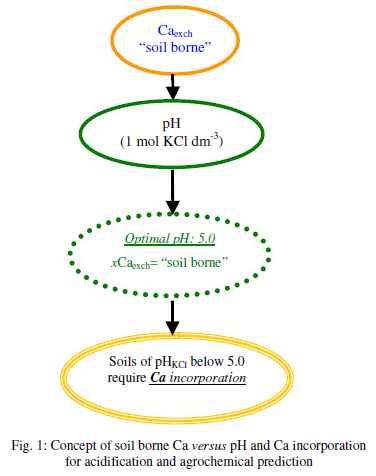
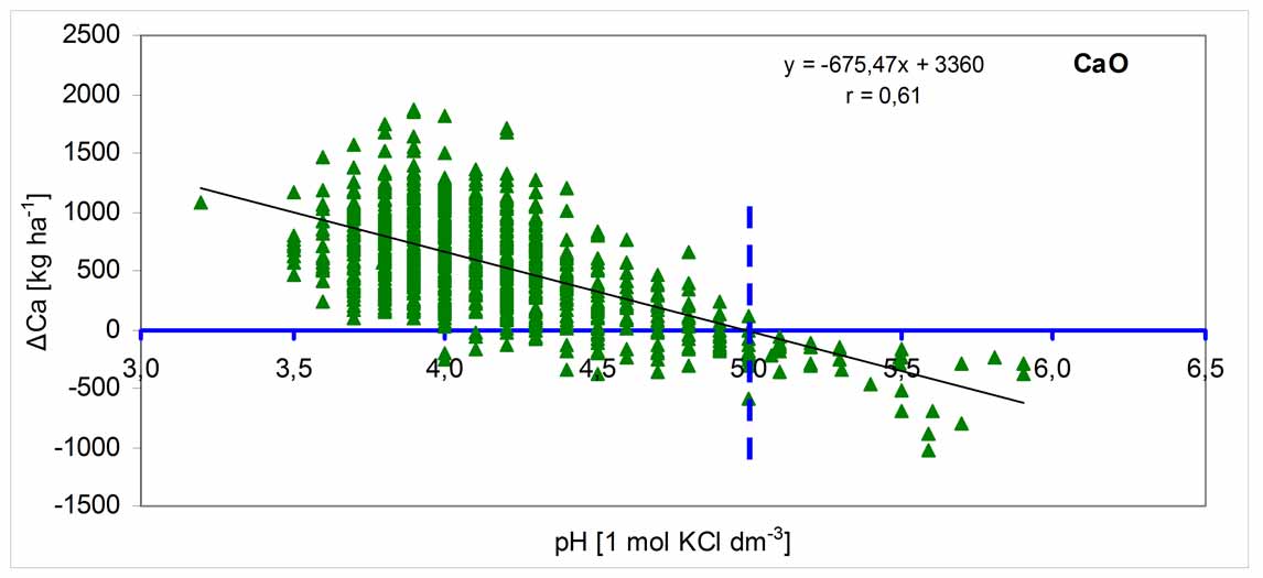
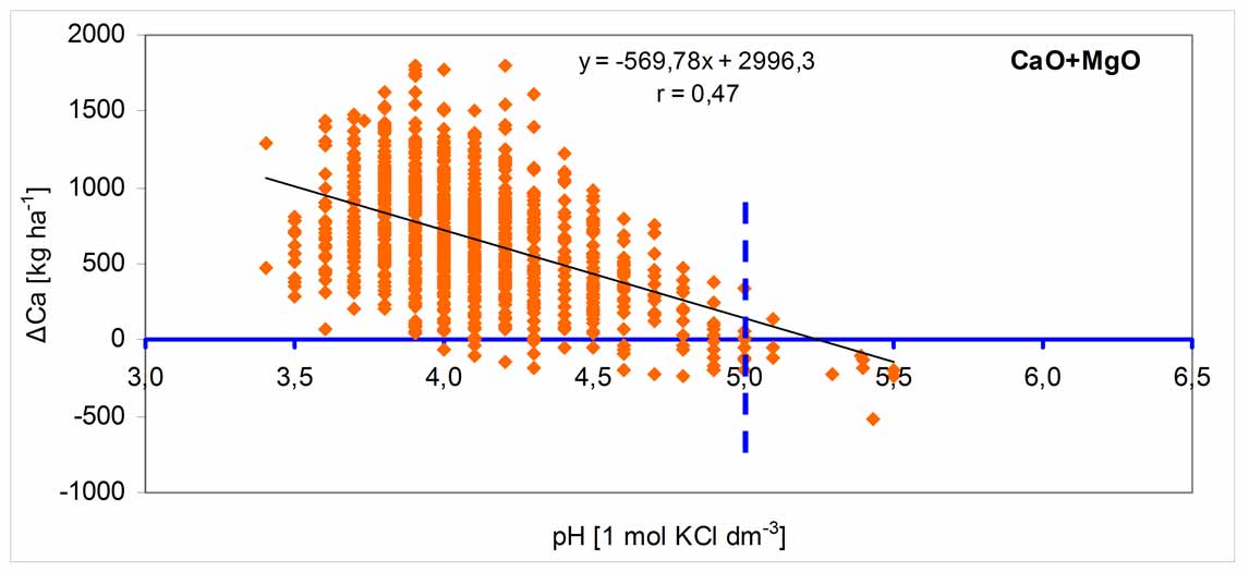
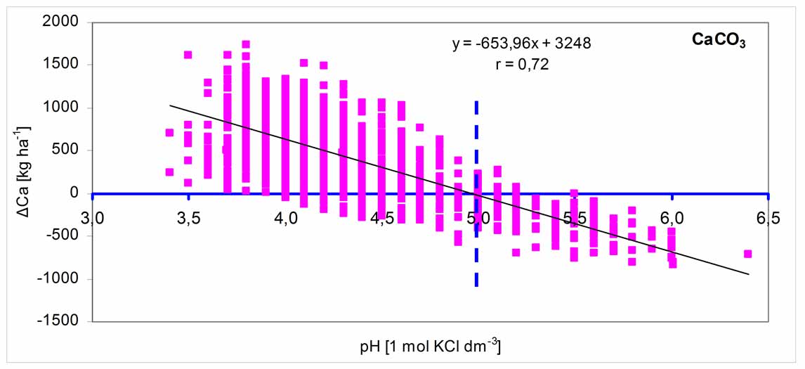
1. Concept outline
The amounts of Ca currently in the soils, i.e., „in situ” and Al as well as H+ are the core factor that regulates soil pH. Therefore the efficiency of soil pH improvement and stabilization should be based mostly on the real amounts of Ca incorporated into the soils, than the aglime rates, as currently practiced in agriculture.
It is assumed that, the Ca saturation of the cation exchange maintains soil reaction at a given pH. Below this level the situation worsens and beyond, therefore improves. The difference (∆Ca) between the steady state (initial pH) and the predicted one is the real amount of Ca (and not liming materials) to incorporate for improving and maintaining soil pH. The concept is briefly illustrated below (Fig. 1).
2. Theoretical and experimental considerations
The elaboration of the concept was performed on the basis of the following assumptions:
- Are pH measurement and acidity determination (Al + H+ mainly) enough for effective regulation of soil pH?
- Is the consideration of Ca instead of aglime rates helpful for full control and stabilization of pH of very acid soils?
- May CAB (Calcium-Aluminum-Balance) and PGC (Proton Generation-Capacity) indices be applied for calibrating biomass and yields of crop plants?
A 3-year study was performed for evaluating acidification impact, and simultaneously predicting agrochemical response of two crop plants (winter wheat and sugar beet). The following parameters/factors were considered: very acid arable land (pH0–60cm 3.8 – 4.4); three (3) aglimes (CaO – 80%, CaO/MgO – 60/20, CaCO3 – 52%) and four (4) rates 0, 500, 1000, 1500 kg as CaO ha-1). Next, nitrogen was applied as NH4NO3 at the rates 0, 60, 120, 180, 240 kg N ha-1.
3. Data validation and quantification :
Matheus H Mortene
Unicamp Faculty of Technology – FT, Brazil
Title: Identification of hydrologic-landscape regions in Piracicaba, Capivari and Jundiai rivers basins, Brazil
Time : 14:45-15:05
Biography:
Matheus H Mortene is an Environmental Engineer with experience in the use of Geographic Information Systems-GIS. He works on the development of techniques for watershed management and studies the impact of climate change on agriculture. The present study was developed as a master's thesis at the School Technology of State University of Campinas, Brazil and collaborates with the management of water resources in the watersheds of the Piracicaba, Capivari and Jundiaí Rivers.
Abstract:
Today, hydrology faces the challenge of finding a hydrological classification model of river basins that can be complete, comprehensive and at the same time efficient, collaborating in the elaboration of hydrological studies and the identification of favorable areas to water storage. The hydrologic landscapes classification method, which summarizes in a single layer the factors that affect the hydrological cycle, have been applied in the Piracicaba, Capivari and Jundiaí rivers basins, located in the state of São Paulo, Brazil. The hydrologic landscapes classification method were used as evaluation units, data on climate, soil and aquifer permeability and relief, in order to prove the efficacy of the method in identifying favorable areas to water storage. Each pixel has received a value of HLR - Hydrologic Landscape Region, which summarizes hydrological characteristics of the site. To evaluate the usefulness of this approach, the annual water yield in the sub-basins was calculated using flow data from the main river basins. This value is necessary to identify the factor "m" (from Fuh’s equation), parameter associated with watershed characteristics, such as slope and water retention capacity. The values found for "m" collaborate with studies, proving that the parameters chosen as evaluation units are effective for identifying water storage areas. The favorable and unfavorable areas for water storage were identified and overlapped with the land cover map to evaluate the conditions of protection and management. The study highlights the high occurrence of pasture and sugarcane crops in favorable areas to soil water infiltration and also the high occurrence of urban in unfavorable areas. The classification in hydrological landscapes has proved to be an effective tool to identify areas of soil water infiltration and it can also be collaborated with projects to increase production and storage water in watersheds.
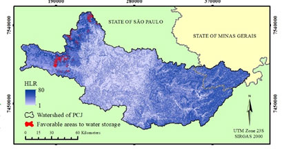
Figure 1: Hydrologic-Landscape Regions (HLR) identification and favorable areas to water storage in Piracicaba, Capivari and Jundiaí Rivers basins.
Sultana Nasrin Baby
RMIT University, Australia
Title: Monitoring simulation for flood risk prediction using 3D analysis and SWAT in Ary creek watershed
Time : 15:05-15:25
Biography:
Sultana Nasrin Baby has been a Senior GIS Officer at the City of Whittlesea in Melbourne Australia for the past 3 years. Prior to this role she worked at Bass coast Shire Council. She is also pursuing PhD in the School of Mathematical and Geospatial Sciences at RMIT University. She has completed her double Master’s degree in GIS and Remote Sensing at Dhaka and Monash University. Her interests are geospatial science applications in water resources, exploring new spatial technologies and climate change modeling.
Abstract:
For many years, the Ary creek watershed in Inverloch has been flooding and causing great problems to the inhabitants as well as the environment. This study uses the real-time simulation in ArcGIS 10.3 and 3D in ArcScene 10.3, and the variables obtained from the soil and water assessment tool SWAT such as the land use, soil and slope are the parameters measured to induce the flood. When certain portions of the hydrologic response unit (HRU) land use, soil or slope is changed due to temporal adjustment and climate change, then the model can predict zones of low, moderate and high flood risk. The 3D simulations appear to produce a visual model for decision-making, planning, management and mitigation. The simulation helps in determining the extent of the flood by using animation.
Meryem Moustakim
Abdelmalek Essaadi University, Morocco
Title: Assessment of climate change impact on soil erosion within an agro-ecosystem in Nakhla catchment basing on Caesium-137 and unsupported Lead-210 measurements
Time : 15:25-15:45
Biography:
Meryem Moustakim is currently a PhD student at Abdelmalek Essaadi University, Morocco. She has successfully performed some research collaborations. She is currently working on the application of nuclear techniques to assess the impact of climate change on soil erosion in the northwest of Morocco.
Abstract:
Statement of the Problem: Water erosion is considered as a leading process of land degradation in Nakhla catchment, northwest of Morocco. This agro-environmental threat has negatively influenced on the quality of soil and water in the basin and caused the sedimentation of Nakhla dam. Soil erosion phenomenon could be subject to the impact of climate change due to the effects of periodic droughts and extreme events in the region.
Purpose: Thus, the purpose of this study is to assess the impact of climate change on soil erosion in Nakhla catchment over the last fifteen years, assuming that there has been no significant change in agricultural practices during this period.
Methodology & Theoretical Orientation: Caesium-137, that showed its potential as a reliable soil tracer, was combined with the re-sampling approach to compare soil movements over two periods (1954-2002 and 1954-2017) within an upland agro ecosystem in Nakhla catchment. Then, unsupported Lead-210 was measured to produce data on the mean annual erosion rate over the last 100 years using Mass Balance Model.
Findings: The preliminary results revealed that climate change has not negatively affected soil loss within the investigated agricultural field. Basing on Caesium-137 measurements, the comparative analysis of the soil redistribution estimates showed that soil loss rates have decreased from 36 t ha-1 yr-1 to 29 t ha-1 yr-1. This could be explained by the beneficial impact of the anti-erosive strategies that were implemented in the basin and sustainable agricultural practices applied by the farmers of the region. Quantification of water erosion with unsupported Lead-210 indicated a rate of 24 t ha-1 yr-1 for the period extending from 1917 to 2017.
Conclusion & Significance: The appropriate soil conservation strategies covered the stress generated by climatic disturbances on the natural resources in Nakhla catchment and adapted the basin to climate change.
Nibedita Pani
Pandit Deendayal Petroleum University, India
Title: Divalent iron oxidative process for degradation of carbon and nitrogen based pollutants from dye intermediate industrial wastewater
Time : 15:45-16:05
Biography:
Nibedita Pani is a full time PhD scholar at the Pandit Deendayal Petroleum University, Gandhinagar, Gujarat, India. She is working on industrial wastewater treatment processes in particular Ammoniacal Nitrogen removal processes.
Abstract:
Statement of the Problem: Water pollution resulting from discharge of partial/not treated textile wastewater containing high carbon and nitrogen pollutants pose a huge threat to environment, ecosystem and human health. It is essential to remove carbon and nitrogen based organic pollutants more effectively from industrial wastewater before discharging. In recent years the removal of nitrogen in particular ammoniacal-nitrogen, nitrate-nitrogen from wastewater is a topic of concern. Wastewater arising from textile operations is characterized to have intense color, high suspended solids, very high concentration of ammoniacal nitrogen and chemical oxygen demand. Ammoniacal nitrogen has adverse effect on aquatic life as well as human being. It acts as one of the main contributor of eutrophication, causes depletion in DO level. The task of treating high to very high concentration of ammoniacal nitrogen is difficult.
Purpose: The purpose of this study is to treat high strength ammoniacal nitrogen and COD (chemical oxygen demand) by Fenton Oxidation process with less detention time from dye intermediate manufacturing industrial wastewater.
Methodology & Theoretical Orientation: Present study focuses on removal of Carbon based pollutant in particular COD and nitrogen based pollutants in particular ammoniacal nitrogen by Fenton Oxidation process using Fe2+ and H2O2 as reagents. The study was carried out with high strength wastewater containing initial COD above 5000 mg/L and NH4+-N above 1000 mg/L. The major operating condition like pH was varied and the effective operating condition was derived.
Findings: The maximum degradation was obtained at pH - 3.0. At this pH the removal efficiencies of COD and ammoniacal nitrogen were found to be 77.27% and 74.9% respectively.
Conclusions & Significance: The Fenton process can be the best alternative for the simultaneous removal of COD and NH4+-N from industrial wastewater.
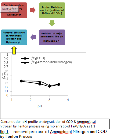
Figure 1: Concentration-pH profile on degradation of COD & Ammoniacal nitrogen by Fenton process using molar ratio of Fe2+/H2O2 as 1:1- removal process of ammoniacal nitrogen and COD by Fenton Process.
Omar Jouzdan
The Arab Center for the Studies of Arid Zones and Dry Lands, Syria
Title: The effect of adding sewage sludge on the productivity of cotton, wheat and corn and the accumulation of some heavy metals in soil and crops
Time : 16:05 - 16:25
Biography:
Omar Jouzdan is a Researcher and Expert on sustainable land management and non-conventional water uses such as treated water, brackish water and gray water. He has research and studies in the field of environmental pollution of natural resources (soil, water and plants), and find appropriate treatment and protection methods. Increase soil productivity to increase farmers' incomes and improve their livelihoods, and thus contribute to agricultural development. He has many scientific researches on the management of the uses of salt water, treated wastewater and sludge in agricultural irrigation, as well as improving the properties of physical, chemical and fertility soil, and increasing yield and production and research on environmental pollution.
Abstract:
This study was conducted in Al-Kamary station in Aleppo province in collaboration between the Arab center-ACSAD and the General Commission for Scientific Agricultural Research in Syria, to study the effect of adding sewage sludge on soil properties and on the productivity of cotton, wheat, and corn. The accumulation of heavy metals namely Cd, Cr, Ni, and Pb were monitored into the soil and plant tissue of the studied crops during three subsequent seasons. Sewage sludge was added to the soil at rates ranging between 6 and 15 ton/ha according to crop N requirement and when its content of heavy metals are less than the thresholds. Yields from the sewage applied treatments were compared with the treatment received chemical fertilizers, and the both of them were compared with the control which did not receive fertilizers or sewage sludge. The results indicated a significant increase in the productivity of some crops grown in the soil received sewage sludge, and this increase reached 15% in cotton, 36% in wheat grain, 16% in wheat straw and 47% in corn seeds compared with control. The increase in productivity also reached 2% in cotton, 16% in wheat grain, 10% in wheat straw and 36% in corn compared with chemical fertilizer application. Increases in the concentrations of heavy metals Pb, Ni, Cr, and Cd were 8.44, 122, 92, and 0.13 mg/kg, respectively in the soil received up to 15 ton/ha sewage sludge compared with control (5.42, 116, 95 and 0.07) mg/kg. However, these concentration remain within the natural limits (0.1-2) mg/kg of Cd, (10-150) mg/kg Cr, (5-500) mg/kg Ni, and (2-200) mg/kg Pb. No significant increase in the concentrations of the heavy metals in the plant tissues of the crops cultivated in soil received sewage sludge at a rate of 15 ton/ha. The concentration of the heavy metals in the plant tissues remained in the natural range of concentration (0.05-1.20) mg/kg Cd, (1-5) mg/kg Cr, (0-4) mg/kg Ni, and (0.1-30) mg/kg Pb, and far from the toxic and the harmful effects on human health according to the international standards.
Tatiana Rondon
Agrosavia, Colombia
Title: Avocado cv. Hass zoning based on aptitude, competitiveness and sustainability criteria
Time : 16:25 - 16:45
Biography:
Tatiana Rondon has her expertise in soil health indicators. Her research has been oriented towards assessing the relations between soil-plant-weather. She has taken part in projects focused on providing agricultural production alternatives and validation of soil health indicators, namely in agricultural regions in Venezuela; however since 2016 she has been working at Agrosavia (former Corpoica) in similar topics.
Abstract:
A study of land use zoning was done on a semi-detailed scale 1:25.000 to classify the Department of Antioquia in Colombia according to its aptitude and competitiveness for Persea Americana cv. Hass. The FAO land zoning and the UPRA (Rural Agricultural Planning Unit) 1:25.000 methodologies were both used subjected to adjustments. Four dimensions were considered in the study: biophysical, economic, social and technological. The biophysical attitude map was realized through secondary information on soil and climate. This information was standardized by means of a field work of characterization of aptitude on eight farms of avocado cv. Hass and the application of geomatic techniques as Kriging. The current use map was obtained employing remote sensing (NDVI as vegetation index). The socioeconomic map of homogeneous zones to produce avocado cv. Hass in Antioquia, was obtained considering social, economic and technological data derived from 21 attributes. The primary information was collected through 212 household surveys which were undertaken to avocado growers on 39 municipalities already identified as producers. A cluster analysis on the data identified three groups of producers which were plotted on a map of homogeneous zones of avocado cv. Hass production. After considering weightings per attribute and dimensions given by experts on avocado cv. Hass, a map of aptitude, competitiveness and sustainability was obtained. The results show that 13.78% of Antioquia department is suitable for avocado Hass, on different ranks: 2.49% suitable and competitive; 3.33% is moderately suitable and competitive; 4.37% moderate to low suitable and competitive; 3.58% unsuitable.
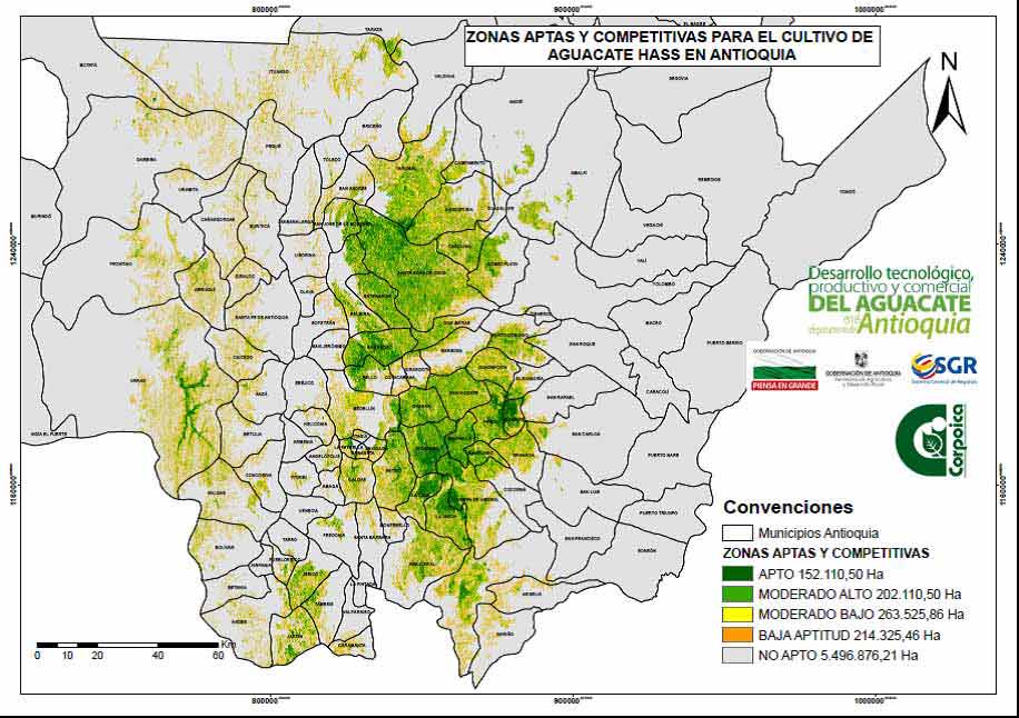
Figure 1: Map of suitable and competitive areas for avocado cv. Hass in the Department of Antioquia.![]()
Paula F Avila
National Laboratory of Energy and Geology, Portugal
Title: Assessement of metalloids phytoavailability in mining soils
Time : 16:25 - 16:45
Biography:
Paula F Ávila pursued her PhD in Environmental Geochemistry; Master's Degree in Geochemistry and a Degree in Geological Engineering. She is a Researcher at the Mineral Science and Technology Unit of the National Laboratory of Energy and Geology (Portugal) since 1993. Her areas of research interest include environmental geochemistry and environmental mineralogy; risk analysis associated with diffuse and/or catastrophic mining contamination, medical geology and human health implications, degraded soil remediation methods including phytoremediation; geochemistry applied to mining; ore mineralogy; minerals and their intergrowth; methods of geochemical analysis; statistical methods applied to geochemical data; development of diffuse and catastrophic contamination modeling methodologies, based on the chemical forms of the trace elements and metalloids, their bioavailability, mobility and reactivity in the different sub-areas of the geosystem.
Abstract:
Trace metals in soil might have origin from anthropogenic sources as metal mining and processing. Soil acts as a metalloid reservoir considered dangerous due to their potential toxicity and persistence in the environment. Metalloids accumulation in soil can degrade its quality. Phytotechnologies use metal tolerant plants and microorganisms to extract, degrade, contain or immobilize metalloids in soil, promoting their restoration. Borralha mine (Portugal) explored tungsten; soil is contaminated with high metalloid concentrations and can benefit from phytotechnologies in its remediation and requalification. Energy crops such as sunflower (Helianthus annuus) and Populus sp., with high potential success to adapt to contaminated soil, assisted by microorganisms (mycorrhizal fungi and plant growth promoting bacteria) that stimulate crop growth, can benefit soil quality and functionality reducing the stress promoted by the contamination. Assessing the environmentally available concentrations and metalloids distribution in soil fractions was the first step in this study. Soil physico-chemical parameters: 52% sand, 42.4% silt, 2.1% clay; pH 5.0; 10.5% OM; 4.2% CO32-, 0.11% N and 113 µS/cm EC. According to the proposed guidelines for Portuguese soil (in mg kg-1 Cu=35; Cd=0.6; As=22; Pb=34 and Zn=85) Cu exceed 24 times de guideline value and Cd 15 times. Sequential chemical extraction: most pollutant fraction consists of metals bounded to sulfides and released under oxidizing conditions in AMD production, nevertheless, Cu and Cd were extracted with acetic acid suggesting linkage to the easily mobilized phases. Selective single extraction to assess bioavailability of metalloids according to the maximum permitted levels for water soluble forms of Cd=0.03 and Cu=0.7 mg kg−1 extracted soluble concentrations of Cd and Cu (H20Cd 3.7X, NH4NO3Cd 8.3X, EDTACd 40X and H20Cu 1.3X, NH4NO3Cu 15.7X, EDTACu 407X) are above toxic levels revealing metal mobility; extraction capacity of metals followed the order of EDTA> NH4NO3>H2O; the mobility and bioavailability of the metalloids declines as Cd>>Zn>Cu>Pb>As.
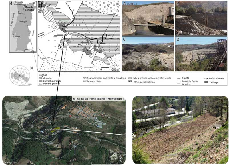
Figure 1: (a) Location of the study area (b) main geological units and (c) wind rose of the prevailing winds. Main sources of contamination: tailings (A, C, D) with huge volumes and pond (B) with rejected muds and slush discharged from the ore process. 1) experimental area for phytotechnologies studies and 2) delimited Sunflower and Populus plots where soil was collected.
Tello Lily
National University of San Marcos University, Peru
Title: Analysis of lead quantification in recreational park soils of the city of Lima, Peru
Time : 16:25 - 16:45
Biography:
Tello Lily has her expertise in soils and passion in improving the quality of them. Her doctoral research is being done in recreational parks in Lima (Peru) and lead. She has developed "assisted phytoextraction" techniques for lead in greenhouse and park bioassays. To achieve efficient phytoextraction she used mycorrhizae and EDTA. She has 20 years of experience as a professor in soils. She teaches Geology, Edaphology and Geomorphology courses at National Agrarian University in Lima, Peru.
Abstract:
The recreational parks of Lima city are green areas where diverse species of animals and plants live. These are also recreational areas located in the Rímac river basin. The GPLM (Gambella People's Liberation Movement) considered were the Bosque Olivar (12º06,04´´S,77º02´05´´O), Campo de Marte (12º04´06´´S, 77º02´29´´O), Pentagonito (12º06´01´´S, 76º59´35´´O), Huachipa Zoo (12º00´52´´S, 76º53´52´´O), Leyendas (12º07´14´´S, 77º05´12´´O) and Kennedy (12º07´18´´S, 77º01´49´´O). The present total of lead in the soils constitute a potential danger to the health of the inhabitants and users. The objective of this investigation was to quantify the total lead content at the GPLM soils. Identification samplings, physical (texture) and chemical (pH, electric conductivity, organic matter, CIC) analysis were performed for soil samples of each park. Those parks that showed contamination of lead were subjected a detailed sampling with additional total lead analysis. The mean values of total lead in soils of the GPLM Bosque Olivar (170 ppm Pb), Campo de Marte (226 ppm Pb) and Pentagonito (159 ppm Pb) were found to be above that allowed by the Environmental Quality Standards (ECA-Emission Control Areas)-Peru: 140 ppm). In park Leyendas was determined that eight of the 98 hectares were contaminated (234.5 ppm Pb) and Huachipa Zoo 0.7 of 11 hectares were contaminated too (266 ppm Pb), while Kennedy Park did not exceed the ECA (56 ppm Pb).
Yasser Abbasi
University of Twente, Netherlands
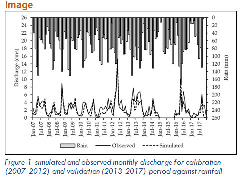
Title: Watershed modeling of sediment and chemical transport in the Malewa river basin, Kenya
Time : 16:25 - 16:45
Biography:
Yasser Abbasi is PhD student in department of water resources at the Faculty of Geo-information Sciences & Earth Observation (ITC) of the University of Twente (NL). His background is soil and water science. Since 2015 he has been focusing on water pollution in the Lake Naivasha, Kenya. This paper presents a part of his research for modeling agrochemicals transportation in the watershed.
Abstract:
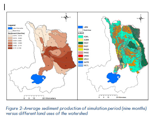
The sediment mobilization and transport behavior and agrochemicals loading of the Malewa river draining into lake Naivasha, as a major fresh water resource, is a critical issue in relation to water quality and ecosystems in the watershed. In this study, ArcSWAT v. 2012 was used to estimate discharge, sediment and pesticides (i.e. Lindane, Methoxychlor and Endosulfan) transport in the Malewa river basin. The model was calibrated and validated in monthly steps using SWAT-CUP tool in which the sequential uncertainty fitting version 2 (SUFI-2) algorithm was used to perform the calibration-validation and sensitivity analysis. SWAT was calibrated using water level gauge data, as well as DTS-12 digital turbidity sensor for suspended sediment transport. Pesticide residues were sampled at three locations using passive sampling technique and determined using laboratory gas chromatography. The sensitivity analysis of the discharge-related parameters indicated 15 sensitive parameters among which curve number (CN2) was the most sensitive one. The results of calibration (2007-2012) showed that the monthly simulation had satisfactory results with a R2 of 0.74 and NSE of 0.70. The validation (2013-2017) of the discharge simulation also showed R2=0.69 and NSE=0.59 for monthly simulations. The results of the model calibration for monthly sediments also showed satisfying results based on R2 and NSE factors as their amounts were both more than 0.90. Among the pesticides-related parameters, application efficiency (AP_EF) and pesticides half-life in soil (HLIFE-S) were the most sensitive ones in calibrating the model. Correlation between the simulated and measured pesticides concentrations at upper Malewa and down Malewa showed that although the model mostly overestimated the pesticides loading, there was a suitable trend between measured and simulated results. The peak of pesticides concentration happened during May to mid-July. Finally, the results of this study demonstrated the capability of SWAT model for evaluation of upstream to downstream suspended sediment and pesticides transport.