Matheus H Mortene
Unicamp Faculty of Technology – FT, Brazil
Title: Identification of hydrologic-landscape regions in Piracicaba, Capivari and Jundiai rivers basins, Brazil
Biography
Biography: Matheus H Mortene
Abstract
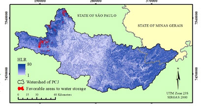
Today, hydrology faces the challenge of finding a hydrological classification model of river basins that can be complete, comprehensive and at the same time efficient, collaborating in the elaboration of hydrological studies and the identification of favorable areas to water storage. The hydrologic landscapes classification method, which summarizes in a single layer the factors that affect the hydrological cycle, have been applied in the Piracicaba, Capivari and Jundiaí rivers basins, located in the state of São Paulo, Brazil. The hydrologic landscapes classification method were used as evaluation units, data on climate, soil and aquifer permeability and relief, in order to prove the efficacy of the method in identifying favorable areas to water storage. Each pixel has received a value of HLR - Hydrologic Landscape Region, which summarizes hydrological characteristics of the site. To evaluate the usefulness of this approach, the annual water yield in the sub-basins was calculated using flow data from the main river basins. This value is necessary to identify the factor "m" (from Fuh’s equation), parameter associated with watershed characteristics, such as slope and water retention capacity. The values found for "m" collaborate with studies, proving that the parameters chosen as evaluation units are effective for identifying water storage areas. The favorable and unfavorable areas for water storage were identified and overlapped with the land cover map to evaluate the conditions of protection and management. The study highlights the high occurrence of pasture and sugarcane crops in favorable areas to soil water infiltration and also the high occurrence of urban in unfavorable areas. The classification in hydrological landscapes has proved to be an effective tool to identify areas of soil water infiltration and it can also be collaborated with projects to increase production and storage water in watersheds.
Figure 1: Hydrologic-Landscape Regions (HLR) identification and favorable areas to water storage in Piracicaba, Capivari and Jundiaí Rivers basins.


